
It’s time to ditch the colouring pencils, scissors and cellotape…
A new way to visualise titles and land has arrived!
Gone are the times of having to wait weeks for a ‘hard copy’ map, now you can have a digital solution available instantly that plots your titles straight onto a map, replacing antiquated processes efficiently and effectively, saving you both time and money.
You are also able to view intersecting titles, pending application and discharge data as well as any OCOD and CCOD data that is available on those titles. As well as help users to identify boundary issues, unregistered land and ransom strips.
Regardless of the quantity of titles to be plotted or the size of area the titles span, you can visualise your titles on one digital map, zooming in and out as well as marking up significant points of interest, and creating customisable links with permissions specified by yourself to assist with client briefing and collaboration.
Illustrative Map is incredibly useful for portfolio transactions, especially when there are properties in different parts of the country. We can interact with different locations on one map, which improves efficiency and reduces the disbursement costs payable by our clients.
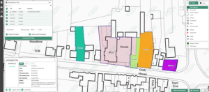
Understand full extent of title seamlessly
Illustrative Map’s capabilities can help you to understand land composition; identify ransom strips, unregistered land, ownership information, and gain an understanding of the full extent of titles seamlessly.
Make an Enquiry
or call us on +44 (0)800 240 4746
![]()
Case Study: Hear what one of our clients has to say
Digitalised mapping helps lawyers and clients alike
Read NowBenefits
- Results are available instantly online, meaning no wait times of up to 9+ weeks as is the case for other solutions in the market
- Virtual collaboration – Create and share with colleagues and clients in the office or at home
- Clearer visibility of information
- Identify boundary issues, unregistered land and ransom strips
- Increased accuracy with less room for human error
- Utilise legal training and expertise rather than wasting time and client money colouring in by hand
- No longer need to visit prospective development sites
- Be more informed – Identify potential ownership issues at start of transaction
- Reduce carbon footprint with a digital solution
- Not restrained by size or time – an Illustrative Map can be archived and revisited any time
Features
- Fully interactive map with ability to annotate digitally and attach names to notes
- Pending application, OCOD and CCOD data
- Ability to order OC documents from within the solution
- Direct link to Companies House’s Register of Overseas Entities.
- Ability to add additional titles to existing and previously purchased Illustrative Maps
- Ability to create customisable links
- Unlimited printing- both basic print and the option to purchased enhanced printing
- No restrictions on size – You can have as many titles or geographical spread as you need
- Able to share with your clients and colleagues easily
- Pricing is based per title
- PDF format available
- Save multiple views of the map, allowing key points of interest to be highlighted and reviewed independently if needed
During the process of setting up a new development transaction, I ordered an Illustrative Map as part of my title investigation which helped to identify a parcel of land my client owned but had forgotten about. Only by using the Illustrative Map and investigating the information was I able to identify this. Going forward I'll be recommending this product to all of my clients as part of every site set up.
 Illustrative Map: Just one of our Instant Products…
When it comes to gathering information about your clients’ commercial properties, time is of the essence. That’s why we offer a suite of instant products designed to provide you with accurate and organised insights without any delays. They not only compliment each other but also excel independently. Whether you choose to use 1, 2, or all 3 of these solutions, their impact on your business will be significant.
Commercial Real Estate
A few examples of what else we offer
Data Snapshot
Empowers real estate lawyers to create a rapid risk assessment of their clients’ land or property, before a search has even been ordered
ForeSite Mapping
Provides users with the ability to overlay hundreds of crucial data layers on street view, B&W and coloured maps
Illustrative Map
Synthetic Case Studies

Analysing Complex Boundary Differences with GIS Mapping
Our client was negotiating across 150+ sites nationwide, facing challenges with GIS boundary data accuracy and discrepancies between Land Registry boundaries and their own records. While they initially requested compliant plans for all sites, our analysis showed a more tailored, efficient approach was required to meet their objectives.
Read more
Multi-Site Title Investigations Completed in Under an Hour
Efficiently and accurately mapping the property titles linked to a university as part of pre-site investigation activities. By utilising Search Acumen’s commercial platform, we aimed to provide comprehensive insights within a tight timeframe.
Read more